top of page

Laser Scanning
Drone Mapping
Reality Capture Services!
Accelerate your business growth with our services

Laser Scanning and BIM Creation
Date: November 2022
Location: Dandenong, VIC
The client required an as-built BIM (Building Information Modeling) for an industrial building slated for renovation.
We conducted a comprehensive laser scanning process, completing over 700 setups using a terrestrial laser scanner. The collected data was then processed and the point cloud was exported into Revit for conversion to BIM.
This project was completed in partnership with PixelCraft.

Drone Mapping and GPS Data Collection Victoria
Date: June 2021
Location: Tarneit, VIC
This is a drone mapping project conducted at Tarneit for green field residential development.
For the drone mapping, very high resolution images and control points were captured for processing and a 3D model was created.
Location: Tarneit, VIC
This is a drone mapping project conducted at Tarneit for green field residential development.
For the drone mapping, very high resolution images and control points were captured for processing and a 3D model was created.

Laser Scanning Melbourne
Date: Jan 2024
Location: Melbourne, Vic
We conducted a laser scanning for a project in Melbourne for capturing an existing building for renovation purposes. The point cloud was provided to the client for further processing and conversion to BIM (Building Information Modelling).
Location: Melbourne, Vic
We conducted a laser scanning for a project in Melbourne for capturing an existing building for renovation purposes. The point cloud was provided to the client for further processing and conversion to BIM (Building Information Modelling).

BIM modelling and 3D rendering Melbourne
Date: June 2023
Location: Melbourne, Vic
This was a project for an architect comapny in Melbourne to create a BIM (Building Information Modelling) from point cloud and processing the BIM to be visualised and rendered using advanced 3D rendering techniques.
Location: Melbourne, Vic
This was a project for an architect comapny in Melbourne to create a BIM (Building Information Modelling) from point cloud and processing the BIM to be visualised and rendered using advanced 3D rendering techniques.

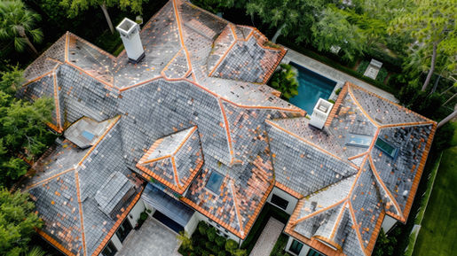
Roof Inspection
Date: February 2024
Location: Melbourne, VIC
This project involved a roof inspection using a drone to assess the current condition of an existing building. Due to safety concerns, a direct inspection was not feasible. We conducted the drone inspection and provided a detailed report to the client regarding the roof's status.

Laser Scanning
Date: Dec 2024
Location: Melbourne, VIC
This project involved the comprehensive laser scanning of a residential property to facilitate a renovation. A Mobile Laser Scanner was used to capture precise measurements and detailed spatial data of the house. The collected scan data was processed and converted into a highly accurate Building Information Model (BIM) using Revit software through the scan-to-BIM workflow. This Revit model served as a crucial foundation for the architect, enabling them to redesign both the interior and exterior of the property with confidence, precision, and efficiency. The process ensured that the renovation plans were based on an accurate digital representation of the existing structure, minimizing errors and streamlining the design phase.
bottom of page


